
Twin Falls ZIP Coverage
Official postal and local-government sources support a short, cautious Twin Falls ZIP code directory. The principal street-delivery code in reviewed city examples is 83301. Government offices also use 83303 for PO-box mail. USPS bulletins identify 83302 with Rogerson, so it should not be presented as a Twin Falls city resident code. None of these listings supplies a complete official boundary polygon.
| ZIP Code | Areas Covered | Post Office | Notes |
|---|---|---|---|
| 83301 | Primary street-delivery use in reviewed Twin Falls examples | Twin Falls Post Office and Pioneer Station | Verify each full address and ZIP+4 through USPS |
| 83303 | PO-box and government mailing pattern | Twin Falls postal grouping | A mailing address is not a physical parcel location |
| 83302 | Rogerson in reviewed USPS bulletins | Not the Twin Falls city post office | Do not label as a Twin Falls municipal ZIP |
The local quirk is visible in government records. The City Clerk works at a physical 83301 address but receives mail at an 83303-1907 PO box. The County Clerk and Sheriff also use 83303 PO boxes. That difference describes the route for mail, not where the office building or a resident sits.
Twin Falls 83301 Stations
The USPS Twin Falls Post Office listing identifies the retail location at 253 Second Avenue West under 83301. The captured official page provides a postal anchor for this ZIP code directory:
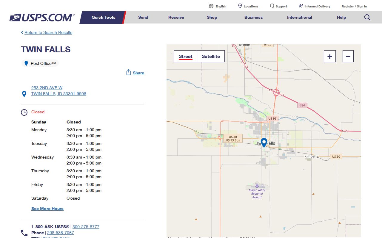
This station listing confirms the location and postal code, but it does not draw the delivery boundary or identify all people receiving mail within it.
A second official point is Pioneer Station at 1376 Fillmore Street. Its captured listing helps confirm another 83301 service location:
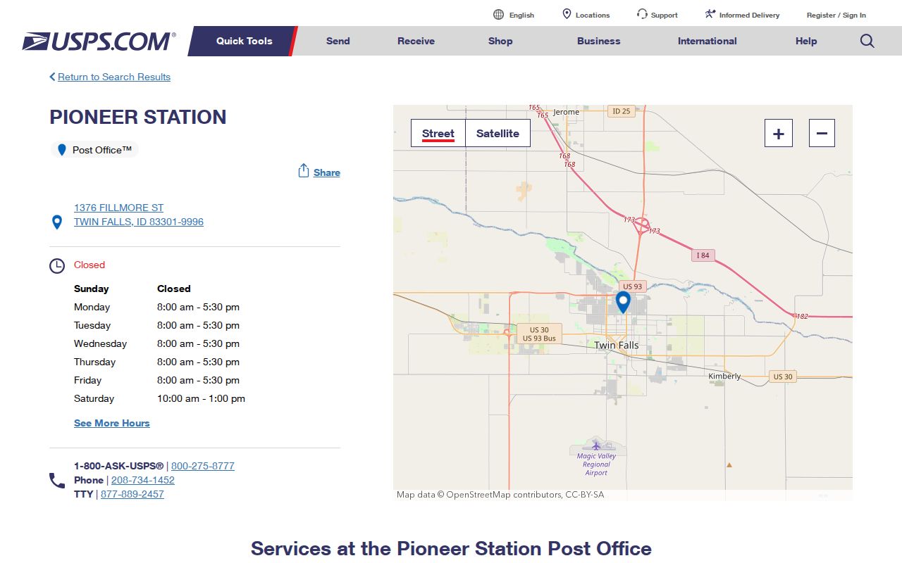
Together, the listings show postal facilities within the code. They still do not prove that every address carrying Twin Falls in a mailing line lies within city limits.
Twin Falls 83303 Mail
The 83303 pattern is easy to misread. Twin Falls city and county offices use it for PO-box mail, while their physical counters can have 83301 street addresses. The City Clerk's mailing address ends in 83303-1907, the County Clerk uses PO Box 126, and the Sheriff's jail mail uses PO Box 306 with 83303-0306. Preserve a published ZIP+4 exactly. Never transfer it to another box or street.
USPS Postal Bulletin 2022 groups 83301 and 83303 under Twin Falls, while listing 83302 as Rogerson. A postal bulletin is a ZIP listing source, not a resident roll or a parcel-boundary map.
Find Twin Falls Residents by ZIP
No official source reviewed offers a complete list of all Twin Falls residents under one ZIP code. Start with the exact person or address and use the ZIP as a check. The county parcel app searches property address or parcel number, not a standalone ZIP list or owner name. Its selected parcel popup may then show owner, mailing, situs, and ZIP fields. The Idaho voter-file request form offers broad political geography, not a simple Twin Falls ZIP filter.
- Normalize the complete street, unit, or PO-box line. Do not drop an apartment, building, or suite label.
- Verify the delivery code and ZIP+4 with the official USPS address lookup or station information.
- Search the Twin Falls County parcel app by property address or parcel number when the question concerns land.
- Read the selected popup's situs and mailing fields separately. Capture the parcel ID and legal description for follow-up.
- Use the custodian's own search or request route for voter, permit, deed, or other records. A ZIP alone is rarely enough.
Once the postal check narrows the search to a named road, the Twin Falls street directory workflow explains address and parcel evidence at street level. It does not turn mail delivery into proof of current occupancy.
Twin Falls ZIP Search Fields
Each portal asks a different question. This field comparison prevents an unsupported “search everyone in 83301” approach. The parcel app can return ZIP data only after an address or parcel search. USPS validates delivery. The voter request and registry tools have narrower statutory purposes.
| Official tool | Accepted starting field | What ZIP can show | Main limit |
|---|---|---|---|
| USPS address lookup | Exact street, unit, city, state | Delivery ZIP and ZIP+4 | No resident identity or city-limit ruling |
| County parcel app | Property address or parcel number | ZIP fields in selected parcel details | No standalone ZIP-wide resident filter |
| Idaho voter file request | Defined report and geographic scope | Not a simple city ZIP query | Law and certification control release and use |
| Idaho registry ZIP tab | ZIP within that registry | Only records within the registry | Not a general resident directory |
The ZIP code directory should therefore guide source selection, not imply a unified ZIP-based database. Keep the date and purpose of each result with the address.
Twin Falls Unit Number Rules
Twin Falls Public Works/911, Planning and Zoning, and Building Safety share parts of local addressing. The city's 911 Communications guidance requires numbers to face the street and remain visible from the travel way, with mailbox, driveway, or entry marking when a structure is set back. It also publishes a 4, 6, 8, 10, and 12-inch size schedule based on distance.
Multi-building sites use building, floor, and unit patterns. Official examples include 1601, 1301, and 1101, while large sites are handled case by case and leading zeros are avoided. A permit project label, USPS unit, and parcel popup may thus differ in format without describing different places. Preserve every unit component before checking a ZIP code.
Note: A parcel ID, street number, permit case, legal description, and postal ZIP are separate keys; save each exactly as its source prints it.
Twin Falls ZIPs Versus City Limits
The city's 2024 National Community Survey gives a direct warning about Twin Falls ZIP code boundaries. Its sample began with USPS ZIP lists, then compared addresses to city limits because ZIP service can extend beyond the municipality. Multi-family units were sampled at a stated 5:3 ratio. The survey method shows why a Twin Falls postal label is not enough to classify an address as inside the city.
Census ZIP Code Tabulation Areas add another layer. ZCTAs are statistical geography created for data reporting, not USPS delivery routes. A Census map may be useful for broad population context, but it cannot replace address-level USPS verification or a city boundary and parcel check.
- ZIP and ZIP+4
- The five-digit code groups delivery geography; the added four digits narrow a delivery segment for a specific address.
- PO-box ZIP
- A code used for mail delivered to boxes rather than a claim about a building's physical location.
- Unique ZIP
- A code assigned for a high-volume organization. No separate Twin Falls example was verified in the research.
- Carrier route
- A postal delivery sequence within a ZIP, not a city ward, parcel boundary, or list of residents.
Map Twin Falls ZIP Evidence
A reliable map comparison uses three layers separately. USPS confirms the delivery label. The county parcel app ties an exact address to a parcel ID, legal description, and current assessment fields. Twin Falls city maps identify subdivisions, future land use, street maintenance, and the original townsite. None substitutes for the other.
The city maps hub includes subdivision and data-hub resources. Named areas such as Twin Falls Original Townsite, Canyon Park, and Candleridge may help distinguish local geography, but subdivision names are not postal codes. When an old directory uses an obsolete unit form or street label, the legal description and subdivision are often stronger bridges than a modern ZIP.
Can a ZIP identify who lives there? No. It can narrow delivery geography, while names and addresses must come from a lawful, source-specific record. Even an assessor owner field or voter address does not alone prove present occupancy.
Limits of Twin Falls ZIP Lookup
No official current ZIP boundary polygon, population table by delivery ZIP, split history, or complete carrier-route map was found for Twin Falls. The honest fallback is address-level USPS verification, followed by the city boundary or parcel tool relevant to the question. Do not draw a precise boundary from station locations or bulletin groupings.
The same restraint applies to people records. A PO-box address shows where mail went. A situs address shows where a parcel lies. A mailing address in an assessor record shows where notices are sent. Each can be accurate while pointing to a different place. Use the Twin Falls ZIP code directory for geographic triage, and confirm facts with the office that created the underlying record.